


Maracalagonis, a rural centre with a splendid coast
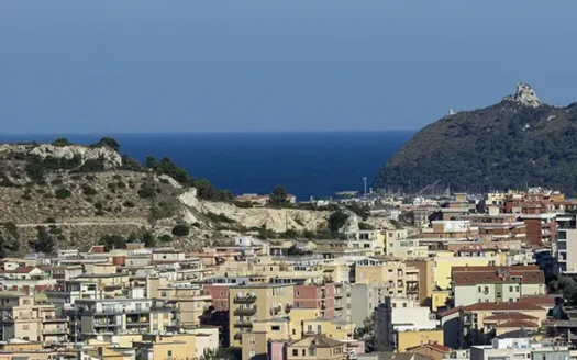
The village of Maracalagonis (86 m asl – about 8,000 inhabitants) is in the eastern area of the plane Campidano of Cagliari, about 17 kilometres from the capital. Its territory is predominantly hilly with holm oaks groves and Mediterranean scrub. This municipality, however, extends over a vast area, from the mountains of Punta Serpeddì and the Oasi dei Sette Fratelli to the well-known coastal locations of Geremeas and Torre delle Stelle.
name
Origin and interpretation of the name are quite controversial. It should anyway derive from the union of the separate names of the two ancient villages of Mara and Calagonis.
economy
Activities are typical for a rural centre extending up to the coast. Alongside the traditional agricultural and pastoral activities, the village is well known for artisan productions, such as typical sweets, Sardinian brocade costumes and basketry. Nevertheless, the village has developed some catering and tourist accommodation activities, encouraged by the natural beauties of coastal locations such as Geremeas, Baccu Mandara and Torre delle Stelle.
a bit of history
Maracalagonis territory has been inhabited since the Eneolithic, as evidenced by the remains of a necropolis in locality Cuccuru Craboni. Remains of nuraghi, a necropolis and the village of Cann ‘e Sisa, on the other side, document the different phases of the Nuragic era. While the remains of a Punic temple and two sandstone statues of the god Bes (kept in the National Archaeological Museum of Cagliari) in locality Carroi attest to the Phoenician and Punic presence. During the following Roman domination, when several villages were born including Mara, the territory became the “granary of Sardinia”.
In the Middle Ages, the territory was part of the Giudicato di Càralis. After it fell, it became the property of the Counts della Gherardesca until 1258. In 1324, after the Aragonese conquest, Maracalagonis was born from the union of two adjacent rural locations. After various and successive changes of ownership, in 1839 the territory became part of the dominion of the Savoy. In 1848, it acquired its independence.
the old centre
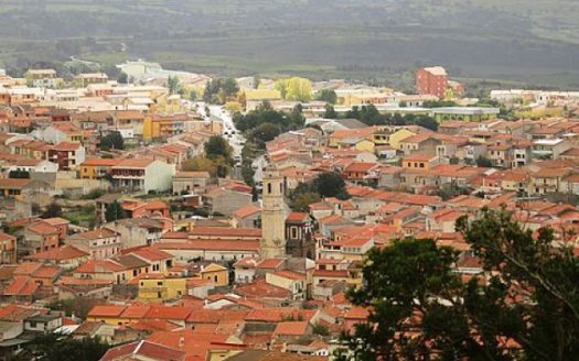
Maracalagonis, interested by a recent strong building growth, is characterized by the position of the houses, that are organized according to grids repeating the agricultural lots’ one.
Alongside the typical Campidanese house with a courtyard in front, a new type of house has later developed. It consists of two-story buildings with the home at the end of the lot, and the service building flush with the street.
We find several interesting buildings in the old centre. The parish church dedicated to Santo Stefano (1227) today presents the different architectural styles of the various renovations. The building known as the Old Town Hall dates back to the end of the 19th century. Arab-style workers built the Church of Nostra Signora d’Itria in Romanesque style at the end of the thirteenth century. The small Church of Santa Lucia Martire is a single-nave church dating back to the 17th century.
the archaeological remains in the surrounding area
You find various archaeological remains in the village surroundings, documenting the long history of this area. The remains of giants’ tombs were brought to light in Murta Sterria ‘e Pizzus; of a sacred source in Cuccuru Crobis; of various types of nuraghi, and also of residential settlements in Crux’e Lillius, and Ganni.
Unfortunately, however, many of these sites are today abandoned, as is the case of the Sirigraxiu site, a residential settlement built near a nuraghe a few kilometres to the village. The various findings attest to the frequentation of this site from the Nuragic and Punic eras up to the fifteenth century. The same happens in the abandoned Rio Sicci site, where a particular Byzantine tomb with a barrel-vaulted ceiling was brought to light in 2002. Accuracy of the structure and size of the covered room characterize it, and, not least, the founding of eleven skeletons carefully placed next to each other.
rural hamlets along the SS 125
Along the SS 125, we find various small hamlets born as residential condominiums in the hilly area of Maracalagonis. They are groups of homes in the greenery, and destinations for lovers of nature and tranquillity, as well as excellent starting points for excursions in the Mediterranean scrub. Among them, Villaggio delle Rose (130 m asl), Villaggio dei Gigli (100 m asl), and the even smaller hamlets of Piscina Nuxedda (55 m asl), Baccu Curzu (95 m asl) and Monti Nieddu (135 m asl).
coastal hamlets
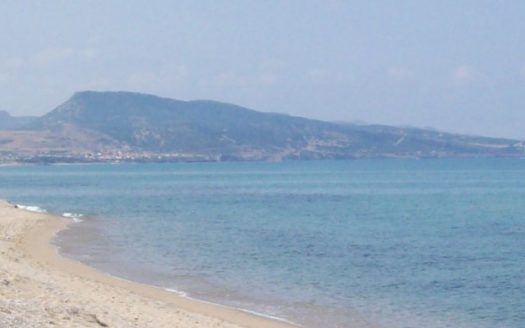
The coastal area of Maracalagonis includes the hamlets of part of Geremeas, Baccu Mandara, and part of Torre delle Stelle. The first beach of Maracalagonis is in Baccu Mandara, where you also find the residential tourist settlement. This beach reaches the end of the Bay of Geremeas, the promontory that closes it to the east. It is a golden sand beach with a flat seabed, which becomes deep after just a few metres. At the back of the beach, you find Geremeas Country Club, a guarded tourist village that offers numerous services all year round.

Here you find info about Comune Maracalagonis
Click to visit
Here you find info about Città metropolitana di Cagliari
Click to visit